The Council Tree Site - An Arapahoe Perspective
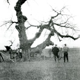
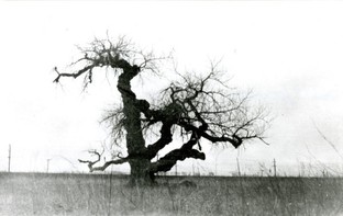 Council Tree - Courtesy Fort Collins Museum of Discovery, H06619
In 1860, a massive cottonwood tree stood in a broad, lush meadow near the Cache la Poudre River’s banks and served as a meeting place for Chief Friday and his band of Northern Arapahoes. It would later become a symbol to white settlers of Native American life, and known to them as the Council Tree. Also in 1860, George Robert Strauss settled about a thousand feet downstream from the tree. At that time, the area along with all the land between the Arkansas River and the North Platte still belonged to the Northern Arapaho as determined by the 1851 treaty.
When researching the history of the Council Tree, there was plenty of information reflecting the historical significance of the tree to Euroamericans, but very little reflecting its significance to the Northern Arapaho. The most direct tidbit we found was a simple quote in a newspaper of Chief Friday’s words: a pioneer woman named Mrs. A.K. Yount who was acquainted with Chief Friday, said he told her, “We meet there.”
When researching the history of the Council Tree, there was plenty of information reflecting the historical significance of the tree to Euroamericans, but very little reflecting its significance to the Northern Arapaho. The most direct tidbit we found was a simple quote in a newspaper of Chief Friday’s words: a pioneer woman named Mrs. A.K. Yount who was acquainted with Chief Friday, said he told her, “We meet there.”
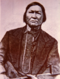 Chief Friday - Courtesy Fort Collins Museum of Discovery, H05384
Less direct and less certain, according to the same article, Mrs. John Rigden recalled playing under the tree as a child and seeing “pieces of cloth tied to the top branches where at one time the body of an Indian woman had been placed on a burial scaffold in the tree.” This story of a tree burial is often mentioned in newspaper articles about the council tree, but aside from Mrs. Rigden’s observations of scraps of cloth, we could not identify the person who actually witnessed the scaffold and body in this particular tree.
C.A. Duncan, in his book Memories of the Early Days in the Cache la Poudre Valley, speculates that in 1862 when a commissioner was sent by the government to make a settlement with Chief Friday, “This meeting probably took place at the council tree on what was later known as the Strause [sic] farm.”1 In our research, we could not find documentation that would corroborate Duncan’s speculation.
C.A. Duncan, in his book Memories of the Early Days in the Cache la Poudre Valley, speculates that in 1862 when a commissioner was sent by the government to make a settlement with Chief Friday, “This meeting probably took place at the council tree on what was later known as the Strause [sic] farm.”1 In our research, we could not find documentation that would corroborate Duncan’s speculation.
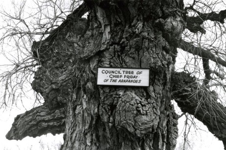 D.A.R. Plaque - Courtesy Fort Collins Museum of Discovery, H14778
A 1938 Fort Collins Express Courier article reports that the conservation committee of the Cache la Poudre chapter of the Daughters of American Revolution (D.A.R.) were trying to save the historic cottonwood which had recently been damaged by a fire. The D.A.R. had previously marked the tree with a plaque. The article states “...it is said, Chief Friday of the Arapahoes held tribal council; and under the longest branch an Indian squaw is buried.” There is no indication of who said this, or when. And later in the article, these details are said to have been “ascertained” by members of the conservation committee. There is no explanation of how or where the D.A.R ascertained this information. (Note that the article states the burial was under the tree, not up in its branches.)
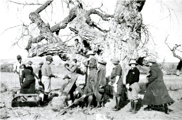
Courtesy Fort Collins Museum of Discovery, H08303
|
Colorado Mountain Club, March 1925 - Courtesy Fort Collins Museum of Discovery, H08305
|
Burris[1], in her introduction to People of the Poudre, notes that, “In North America historical records have seldom been produced by ethnic groups themselves but instead by Europeans (French, Spanish, English, etc.) or Euroamericans, and as such are subject to significant reporter bias. For the Poudre valley, the historical record is problematic on both fronts – lack of material and lack of first person reporting.”
At a meeting of representatives of the City of Fort Collins and the Poudre Heritage Alliance, with Elders of the Northern Arapaho Tribe on February 19, 2016, there was a glimpse of first person reporting regarding how the Northern Arapaho Tribe viewed the Poudre River Valley, as passed down via a well-defined oral tradition. The Elders talked of a large region of the plains and foothills, from the Arkansas River north to the Black Hills of South Dakota, as ‘home’.
The area of the Poudre River Valley, where the Boxelder Creek joined the Poudre River, was noted as a meeting area – where bands of Northern Arapaho would gather periodically, because of the lush grass and abundant game. What the settlers called the Council Tree, was not the reason the Northern Arapaho gathered at the site – trees come and go when you live in an area for hundreds of years. Again, it was the lush grass and abundant game of the area that made this area of the Poudre a favored meeting place.[1]
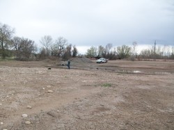 Approximate site of Council Tree, April 2016 - Courtesy of Denise Fisher.
Today, the cottonwood is long gone. The Great Western Railway bisects what used to be the flat, lush meadow. Directly to the west is a gravel-mined pond. To the south are more gravel-mined ponds. Just beyond the Poudre to the east, four lanes of Interstate-25 traffic whines, whooshes and roars. All that seems to remain of the former valley of 1860 are the river and the view of the white-capped Rockies.
In such a transformed landscape, what can written descriptions of the early explorers and settlers tell us about the landscape that the Native Americans enjoyed before being forced off the land?
Ansel Watrous provides an example:
“The waters of the river were as clear as crystal all the way down to its confluence with the Platte. Its banks were fringed with timber not as large as now, consisting of cottonwood, boxelder, and some willow. Its waters were full of trout of the speckled or mountain variety. The undulating bluffs sloped gently to the valley which was carpeted with the most luxuriant grasses. … In coming up the South Platte River they struck the mouth of the Cache la Poudre River at noon, and on the evening of the first day’s travel on that river they camped. Game was plentiful, herds of buffalo were seen on the plains, as well as deer, elk, and antelope. To the travelers the Poudre Valley appeared to be the hunter’s paradise. Trout were caught then along the Poudre River from its mouth to the foothills, and the small streams in the mountains were alive with them.”[4]
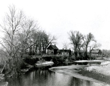 Strauss Cabin circa 1935 - Courtesy Fort Collins Museum of Discovery, H01857
When George Strauss passed through the Cache la Poudre River Valley in 1858, while driving a supply wagon to Camp Floyd, near Salt Lake City, he noted the area as a paradise of game and fish. When it came time to settle down, he recalled his observations of the Poudre River Valley and in 1860 settled on a homestead just west of Timnath.[1]
Laflin notes that Northern Arapaho chiefs White Wolf and Friday, and their bands, gathered in the Cache la Poudre River Valley in the summers of 1863 and 1864, as tensions between Native Americans and Euroamericans were escalating. Laflin continues:
“Chief Friday implored the U.S. government to set aside land for his people on the north bank of the Cache la Poudre, extending from Box Elder Creek to the South Platte River and reaching as far north as Crow Creek. U.S. Indian Agent, Simeon Whitely advised against this, as it would have required relocating sixteen non-Indian families living along the river in the proposed area. As the government negotiated with the Indians, homesteaders were busy excavating ditches, buildings shelters, planting crops, and transforming the land.”[1]
Burris points out that it did not seem to factor into Whiteley’s rejection of Friday’s request, that the squatters were illegally occupying the area.[2]
She concludes:
“By 1869, Friday had joined the rest of the Northern Arapahos under Medicine Man in Wyoming, giving up hope for a reservation on the Poudre. In January 1870, Washakie, the Shoshone Chief on the Wind River Reservation, allowed the Arapahos temporary accommodation. By 1878, a permanent place was made for the Northern Arapaho at Wind River. Friday died on the Wind River Reservation in 1881.”
